-
 The Official Tourism Website for Destination Conwy
-
My Planner
To build your own Itinerary, click  to add an item to your Itinerary basket.
Already saved an Itinerary?


Walking the Wales Coastal Path in Conwy
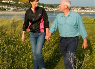
Wales is the first country in the world to have a footpath that surrounds the whole of its coastline. The path runs for 870 miles. Here in the county of Conwy, we have a beautiful section of the path. A lot of the coastal path in our county is flat and has long tarmacked sections, making it suitable for people of all abilities.
Day 1 Abergele – Colwyn Bay
Abergele, meaning mouth of the River Gele, is a small market town which lies along the coast, surrounded by woodland covered hillsides. The town itself is steeped in history which dates back to the Iron Age.
One Iron Age hill fort behind the town is called Castell Cawr at Tan y Gopa. This is a lovely walk through a wooded hillside with views over the town and surrounding countryside and coast.
Directions
If taking the train, you will arrive at the seafront in Pensarn. From the train station, the walk is approximately a 5 mile round trip. The buses also stop on Market Street, close to the beach.
From the train station, follow the path in the opposite direction to the beach. You will then come to a roundabout.
Cross the road at the traffic lights on the left.
Then follow the road to the right.
Once under the road bridge, cross the road and you will see an entrance way through some walls into Pentre Mawr Park.
Follow the path to the left through the wooded area.
At the end of the park, you will come out on to the end of Dundonald Avenue.
Turn right and follow the road into town.
When you are at the traffic lights at the cross roads, turn right onto Market Street.
Follow Market Street past the shops and Tesco until you see a large stone gate house and walls.
When you see the gate house, cross over to the same side of the road and follow up the road in front of you (Tan Y Gopa Road). Near to the top of Tan Y Gopa Road, the road follows on to the right past the golf course and then onto the start of the walk.
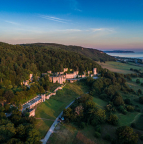
The gate house belongs to a Grade 1 listed country house called Gwrych Castle. It stands in 250 acres of gardens and grounds which overlook the Irish Sea. Gwrych Castle was built by Lloyd Hesketh Bamford Hesketh, heir of the Lloyds of Gwrych, from c.1810. The castle was extensively looted and vandalised, becoming little more than a derelict shell. In June 2018, Gwrych Castle was purchased by the Gwrych Castle Preservation Trust and a ten year programme of works has started, which will see the castle and outbuildings restored. In 2020, it was the home of the popular TV series “I’m a Celebrity…Get Me Out Of Here.”
After your walk around Tan Y Gopa, why not stop for lunch in one of the many cafes,
Public Houses and restaurants in Abergele before heading back to the beach. Once back on the beach, follow the coastal path in the direction of the Castle Cove Caravan Park towards Colwyn Bay (7 miles to Colwyn bay).
Just past Abergele is the village of Llandulas. Llandulas lies beneath the limestone hill of Tan-yr-Ogof (670 ft). This hill has large caves and quarrying of limestone. The limestone from this quarry is a pure form of the rock, making it ideal for the chemical and cement industries. The stone is exported from the 200m long jetty on to quarry boats. You might be lucky enough to see one as you walk past.
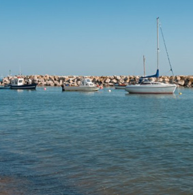
You will know when you are in Colwyn Bay when you get to Porth Eirias. Porth Eirias is a modern looking building on the sea front and has a restaurant and changing facilities. If you need help booking overnight accommodation, the Tourist Information Centres offer a bed booking service. For more information, please call Llandudno on 01492 577577 or Conwy on 01492577566. Alternatively, you can email: llandudnotic@conwy.gov.uk or conwytic@conwy.gov.uk
Day 2 Colwyn Bay – Llandudno
Directions
Make your way from your overnight accommodation back down to the coastal path. Once on the path, head towards Rhos on Sea.
Pass the golf club on the coastal path and through Penrhyn Bay.
Once through Penrhyn Bay, you will start your ascent up the Little Orme.
Rhos on Sea is about 1.7 miles from Colwyn bay and is a charming seaside resort. It is named after the Welsh kingdom of Rhos, established there as a sub-Kingdom of Gwynedd. To explore more of this fascinating town, why not follow the Rhos on Sea Heritage Trail. The trail takes in 25 historic sites in about 3 hours, including St. Trillo's Chapel. The chapel is the smallest church in Britain and its altar stands on a natural spring of clear water dedicated to St Trillo in the early sixth century AD. The trail also includes the remains of Bryn Euryn.
Bryn Euryn is a limestone hill which is a Site of Special Scientific Interest for its mix of grassland and woodland. The hill was once the location of a 6th century hillfort and Llys Euryn - a house dating from the 15th century. It has a number of paths including the Summit Trail, which links Llys Euryn and the fort at the summit. The heritage trail finishes back on the coast near the golf club.
The Little Orme is one of the two limestone headlands in Llandudno Bay. It is covered with grassland and has natural and man-made cliff faces, which provide ideal nesting areas for birds. The Little Orme boasts beautiful views of the North Wales Coast. The walk from Rhos on Sea to Llandudno is about 4 miles.
Day 3 Llandudno Great Orme - Conwy
Llandudno is a Victorian seaside resort framed by two headlands: the Great Orme and Little Orme. The main North shore beach promenade runs for two miles from the Little Orme through to the Great Orme. Llandudno pier, off the promenade near the Great Orme, was built in 1884 and is the longest pier in Wales.
The Great Orme’s Country Park is a Special Area of Conservation, Site of Special Scientific Interest and Heritage Coast for its different habitats, which include heathlands, sea cliffs, limestone grassland and woodland and supports a wide variety of plants and wildlife. The history of the Great Orme is believed to be over 350 million years old. The Great Orme offers amazing views across the sea towards Anglesey and Snowdonia.
There are a number of walks you can follow to explore the Great Orme. These include nature and history trails. You can find out more about Great Orme walks here.
The road around the base of the Great Orme is Marine Drive. The road runs for 5 miles from North Shore to West Shore. You can download an audio trail, which gives details on the varied environment, history, archaeology and attractions that the Great Orme has to offer.
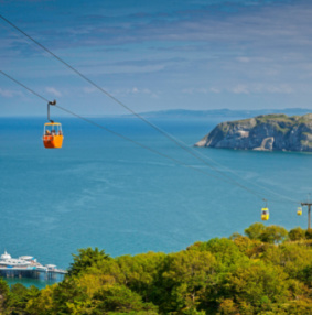
If you would prefer a more relaxing journey to the summit of the Great Orme, you can catch the Great Orme tramway which runs every 20 minutes from Church Walks. If catching the tram, at the half way station you can disembark and visit the Great Orme Bronze Age Copper Mine. Alternatively, enjoy a cable car ride to the summit of the Great Orme Country Park. Llandudno has the longest passenger cable car system in Britain. The cable car runs from Happy Valley to the summit of the Great Orme, 679 feet up in the air providing amazing views of Llandudno Bay and the Irish Sea.
Whist in Llandudno, why not visit the Tourist Information Centre (located in the Victoria Shopping Centre) for more information about what to see and do in the town. You can also purchase a variety of maps and gifts.
The next section of the path is from Llandudno’s West Shore through to Deganwy Castle. The path runs for about 2 miles and overlooks the coast and Conwy Mountain.
Directions
Starting at West Shore, follow the path until you get to Marine Cresent.
Whilst on Marine Cresent turn left on to Sefton Terrace then turn left over the bridge on to Station Road.
When on Station Road, turn left and then take the next right onto York Road.
York Road then leads on to Gannock Park.
Further up Gannock Park on the left, you will see a path that leads on toward Deganwy castle.
The path leads to number 5 on the route map around the castle.
When you have followed the path around the castle, make your way back down the hill to the coastal path.
The walk around the castle takes about an hour, with gradual slopes and uneven ground.
The site of the castle was the seat of Maelgwn tyrant of Gwynedd in the sixth century, but was destroyed by the Saxons in the 9th century. In the late eleventh century, Robert of Rhuddlan rebuilt the castle. The castle was destroyed and then rebuilt by Henry III in 1245-50 but was then destroyed again by Llywelyn ap Gruffudd in 1263 to prevent English soldiers taking over the site.
Following the path from Deganwy to Conwy (2 miles), you get a lovely view of Conwy Quay and Conwy Castle. Some of the best picture opportunities of the Castle are just past Deganwy, just before you walk over the river bridge into Conwy.
Day 4 – Conwy
Why not start the day walking back over the river bridge and following the path to the right towards the lovely RSPB Conwy reserve. The site includes grassland, scrubland, reedbeds, salt marsh and mudflats overlooking the estuary. After a morning in the reserve, follow the estuary path back over the river bridge in to Conwy.
Conwy is a beautiful and historically important town at the edge of the national park, with plenty to see and do. The town walls are the most intact in Europe and enclose many historical buildings and quirky shops. Conwy is also famous for the Smallest House in Britain, which once housed a 6ft 3” Fisherman. Other attractions include the 13th century Conwy Castle built by Edward I and a 16th century lavishly decorated Elizabethan town house called Plas Mawr.
Another famous heritage site is the Thomas Telford suspension bridge which was completed in 1826. It harbours wonderful views of the Conwy River and the 14th century merchant’s dwelling Aberconwy House.
Whist in Conwy, why not pop into the Tourist Information Centre (across the road from the castle). The helpful staff can provide you with the town trail leaflet. The town trail is an 80-minute tour of Conwy to see some of the most interesting features of the walled town and UNESCO World Heritage Site. Discover the town’s fascinating history, from early medieval beginnings to the present day. The Tourist Information Centre also provide more information about what to see and do in the town, as well as maps and gifts.
Directions
The town trail ends on the quay in Conwy. Follow the quay opposite the castle and go through the archway.
From here, you will see a path between two houses which leads to the marine walk of Bodlondeb Park.
Following the marine walk of Bodlondeb Park past the school, turn right up Morfa Drive.
Follow Morfa Drive to the end, turn right on to Elis way, go through the car park, past the Mulberry Pub and on to the Marina.
From the Marina, follow the path around the outside of the Golf course to Conwy Morfa beach.
Follow the beach back down to the marina, through Bodlondeb and end the day back in Conwy.
Bodlondeb Park is a mixed woodland which lies on the bank of the Conwy Estuary. The Park is home to a variety of mammals, birds and butterflies. There are good footpaths from the town and also numerous footpaths through the woods with wonderful views over the estuary and out to sea towards the Great Orme.
The Mulberry pub makes reference to the design for the Mulberry Harbours. Mulberry harbours were temporary portable harbours developed during the Second World War to facilitate the rapid offloading of cargo onto beaches during the allied invasion of Normandy in June 1944. A North Walian civil engineer Hugh Iorys Hughes was given the task of proving one of the designs. The prototypes were constructed at the Morfa, with the area transformed into a huge construction site and over 1000 labourers were drafted in.
Conwy Morfa beach is a large sandy bay, which at low tide forms part of the extensive sandy beaches and mussel banks of Conwy Bay.
Day 5 – Conwy Mountain - Penmaenmawr upland walk – Llanfairfeachan
End your walking tour with breath-taking views of the Carneddau mountain range and coast towards Anglesey. For this last section, you will venture off the coastal path to the upland path over Conwy Mountain, through Penmaenmawr and down into Llanfairfeachan. The walk is about 8 miles of hill walking; with some moderate to steep climbs.
Directions
To reach Conwy Mountain from Conwy Quay, walk in the opposite direction to the castle and go through the archway. From here, you will see a path between two houses which leads to the marine walk of Bodlondeb Park.
Follow the path until you have passed the school then turn left up Morfa Drive.
At the end of Morfa Drive, cross the road. You will see a metal Railway Bridge.
Go over the bridge and follow the track end of the trail.
Turn right and you’ll be at the start of Conwy Mountain. This takes you on to the lower path, which is wide but can be muddy. If you would prefer to follow the higher path, follow Mountain Road up the hill past the house until you see a wooden stile and steps on your right hand side. This path is narrow but less muddy.
From the summit, you can enjoy beautiful views of Anglesey and the Great Orme. If you are lucky, you might catch a glimpse of wild ponies.
Follow the path back down the mountain into Conwy. The summit also has an interesting history. There are remains of Neolithic Hut Circles and an Iron Age hillfort called Castell Caer Seion. The site is comprised of a stone walled fort and incorporates more than 50 hut circles and levelled platform houses, with a citadel and outposts.
Follow the path on Conwy Mountain and you will eventually end up on Sychnant Pass Road, near a car park.
Turn left and pass the Pensychnant Nature Conservation Centre. You will see another car park on your right.
Pass this car park to start the Sychnant Pass walk.
Once at number 7, instead of following the path to the right, head straight on and over the Avon Gyrach. The path leads on to the druids circle path on the uplands of Penmaenmawr. The circle is situated close to a pre-historic trackway and was built around 3000BC.
When reaching the druids circle path, turn left and head towards number 2 on the leaflet.
Just after number 4 on the leaflet, you will see the main path heading off to the left. Follow this path past the quarry.
Once past the quarry, you will now be coming into the village of Llanfairfechan. Llanfairfechan is a small Victorian resort which has a history dating back to the Bronze Age.
Pass the quarry until you get to Plas Heulog Holiday Cottages.
Once at the cottages, turn left on to Glan Yr Afon Road. Then right onto Newry Drive. This road leads on to Nant Y Coed nature reserve.
You have the option of investigating the reserve from here or keep following the North Wales path by turning left at the junction of Valley Road, then right on to Terrace Walk.
When you come to a golf course, turn right. Pass the golf course and turn right on to Mill Road.
Follow the road down the hill to the end.
Turn right at the Llanfair Arms and then left on to Village Road.
Follow this road through the village. The road then turns into Station Road.
Pass under the A55. At this point you have the option to follow straight on to the beach in Llanfairfechan or finish your tour here by turning left towards the train station.
Pensychnant is an area of outstanding natural beauty with its diverse wildlife both common and rare, in ancient and Victorian woodlands and heathland. The landscape is rich in archaeological features, from stone circles to medieval houses, which can be explored along the route.
Penmaenmawr was named after Penmaenmawr Mountain, which stands above the sea immediately west of the town. Much of its formerly rounded top has been quarried away for granite, leaving the present-day lower flat top. The uplands above the town have many prehistoric remains, including the site of prehistoric polished stone axe factories on the west slopes of Cwm Graiglwyd near the top of Penmaenmawr. This was once one of the most important stone axe manufacturing sites in Europe.
Nant y Coed nature reserve is a beautiful woodland at the back of Llanfairfechan. An attractive short walk follows the tumbling river. Birds such as the dipper, redstart and pied flycatcher can be seen here.
Once you have completed this itinerary, why not try some of our other itineraries exploring Conwy County? You can find them on our website here.
If you’re interested in finding out more about our beautiful area, why not enrol on our Conwy Tourism Ambassador Programme?
Itinerary Items
Product Information
Gwrych Castle
Abergele
Gwrych Castle is a Grade I Listed country house in North Wales and is one of the first attempts at replicating true medieval architecture in Europe.
Porth Eirias Beach
Colwyn Bay
Visitors to Colwyn Bay can now enjoy the wide sandy Porth Eirias beach and admire the seaside views from the improved promenade and its attractive seating and landscaped areas.
Bryn Euryn Local Nature Reserve
Rhos-on-Sea
Bryn Euryn is a prominent limestone hill overlooking Rhos-on-Sea, with fine views from the summit. It is a rich mixture of grassland and woodland, part of it being a Site of Special Scientific Interest.
Little Orme
Llandudno
The Little Orme is a limestone headland east of Llandudno. It is less developed than its bigger and more famous neighbour, the Great Orme, which makes it great for exploring and a haven for wildlife.
Great Orme Walks
Llandudno
A series of walks of varying lengths up to and around the Great Orme summit in Llandudno.
Marine Drive Audio Trail
Llandudno
This self-guided audio tour allows you to explore the varied environment, history, archaeology and attractions that the Great Orme has to offer.
Great Orme Tramway
Llandudno
Llandudno’s Great Orme Tramway, with its Victorian splendour and charm is waiting to take you on the picturesque, breath-taking, one-mile journey to the summit of the Great Orme Country Park and Nature Reserve.
Great Orme Mines
Llandudno
Walk the 3,500 year old underground passageways that lead to the Great Cavern; the largest prehistoric underground excavation in the world.
Llandudno Cable Car
Llandudno
NOW CLOSED FOR THE 2025 season.
Enjoy a ride on the Llandudno Cable Car during your visit to the beautiful resort. Opened on 30 June 1969 as the longest passenger cable car system in Britain.Tourist Information Centre - Llandudno
Llandudno
Need help with booking accommodation, advice on planning your day, a tasty treat or a locally crafted gift for that someone special? Call into Llandudno Tourist Information Centre at the Victoria Centre.
Llandudno Area Walks
Llandudno
We have listed three different walks below which take you around the Llandudno area. The walks take you from Llandudno around Deganwy, Penrhynside, Nant y Gamar, the Little Orme and the Great Orme.
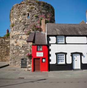
The Smallest House in Great Britain
Conwy
The Smallest House in Great Britain can be found nestled at the end of a terrace of houses on Conwy's quayside. You really can't miss the smallest house and you'd be crazy not to pop in for a look on your way past.
Conwy Castle
Conwy
When King Edward I built Conwy Castle in the late 13th Century it was intended to dominate and intimidate - and it’s still doing its job, competing with Snowdonia’s rugged skyline and winning the battle for our attention.
Plas Mawr
Conwy
Plas Mawr is the best Elizabethan town house in Britain. Located in Conwy, home to one of Edward I’s castles, Conwy is the perfect place for history lovers.
Conwy Suspension Bridge
Conwy
Walk over the River Conwy on Thomas Telford’s Suspension Bridge, with views of Conwy Castle, Snowdonia and the Estuary.
Tourist Information Centre - Conwy
Conwy
Need help with booking accommodation, advice on planning your day, a tasty treat or a locally crafted gift for that someone special? Call into Conwy Tourist Information Centre.

Itinerary Distances
| From | To | Distance * (metric) |
|---|---|---|
| Gwrych Castle (53.28318,-3.60725) | Porth Eirias Beach (53.29485,-3.71542) | 6.58 |
| Porth Eirias Beach (53.29485,-3.71542) | Bryn Euryn Local Nature Reserve (53.30563,-3.75199) | 2.44 |
| Bryn Euryn Local Nature Reserve (53.30563,-3.75199) | Little Orme (53.32244,-3.78261) | 2.49 |
| Little Orme (53.32244,-3.78261) | Great Orme Walks (53.33373,-3.85335) | 4.38 |
| Great Orme Walks (53.33373,-3.85335) | Marine Drive Audio Trail (53.32599,-3.83049) | 1.57 |
| Marine Drive Audio Trail (53.32599,-3.83049) | Great Orme Tramway (53.3276,-3.83595) | 0.36 |
| Great Orme Tramway (53.3276,-3.83595) | Great Orme Mines (53.32997,-3.84892) | 0.81 |
| Great Orme Mines (53.32997,-3.84892) | Llandudno Cable Car (53.32963,-3.83001) | 1.13 |
| Llandudno Cable Car (53.32963,-3.83001) | Tourist Information Centre - Llandudno (53.32369,-3.82906) | 0.6 |
| Tourist Information Centre - Llandudno (53.32369,-3.82906) | Llandudno Area Walks (53.32242,-3.82883) | 0.13 |
| Llandudno Area Walks (53.32242,-3.82883) | RSPB Conwy (53.27873,-3.80446) | 4.61 |
| RSPB Conwy (53.27873,-3.80446) | The Smallest House in Great Britain (53.28227,-3.82827) | 1.47 |
| The Smallest House in Great Britain (53.28227,-3.82827) | Conwy Castle (53.28006,-3.82581) | 0.27 |
| Conwy Castle (53.28006,-3.82581) | Plas Mawr (53.28113,-3.82992) | 0.27 |
| Plas Mawr (53.28113,-3.82992) | Conwy Suspension Bridge (53.28048,-3.82378) | 0.37 |
| Conwy Suspension Bridge (53.28048,-3.82378) | Tourist Information Centre - Conwy (53.28006,-3.82562) | 0.12 |
| Total Distance * | 27.61 miles | |
| Estimated Journey Time | 53 minutes | |
* Approximate distance by road

Ratings
Powered By
![]()
© Conwy County Borough Council. All Rights Reserved